The $23 million road to nowhere in Rocky Fork
Rocky Fork State Park is Tennessee’s wildest state park—and one of the wildest spots in all of Southern Appalachia. Located near the Tennessee-North Carolina border just south of Erwin, the park was created to provide a primitive, minimally developed experience. It is accessed via a narrow one-lane paved road, tightly wedged between the gorgeous Rocky Fork Creek on one side and steep-sloping embankments on the other.
The 2,076-acre park provides the best point of entry for everyone who enjoys the entire 10,000-acre Fork Rocky Watershed tract, which adjoins Cherokee National Forest, the Bald Mountain Roadless Area, the Appalachian Trail corridor, and the recently enlarged Sampson Mountain Wilderness, Rocky Fork is part of the largest swath of undeveloped land between Great Smoky Mountains and Shenandoah.
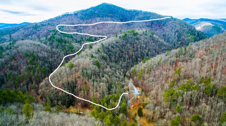
Last November, after three years of relative silence, the Tennessee Department of Environment and Conservation finally presented to the public their plans for the first stage of “improvements” in what was to be a “minimally developed” state park. The centerpiece of the plan is a steep 24-foot-wide, two-lane, paved road that would begin with a bridge over Rocky Fork Creek and extend ¾ mile to a campground and scenic overlook on Flint Mountain.

The accompanying photo shows the approximate route of the proposed road, now estimated by TDOT to be a $23 million dollar project, designed so as to be able to accommodate RVs and 4,000 to 8,000 vehicles per day. Due to the rugged and steep terrain, extensive use of retaining walls, massive road cuts, and metal reinforcement bolted into rock would be required, leaving an ugly scar on Rocky Fork and permanently damaging one of the most pristine watersheds remaining in Appalachia.
If this isn’t what you want to see in Rocky Fork, local activists John Beaudet and Frances Figart suggest a letter to the new Commissioner of TDEC, David Slayers ([email protected]) and/or the interim Deputy Commissioner of State Parks, Anne Marshall ([email protected]), asking that these plans, developed by the previous administration, be re-visited and public input sought to arrive at a better plan that the public supports.
Stay in the loop about the development issue and learn more about this special place by following RockyForkJournal.com and the Rocky Fork Watershed Almanac on Facebook.


