Forget the emotional, mental, and physical strength it takes to tackle all 2,175 miles of the Appalachian Trail — even if we were strong enough to tackle such an endeavor, who has the time? Follow our Appalachian Trail Guide to make the most of your time.
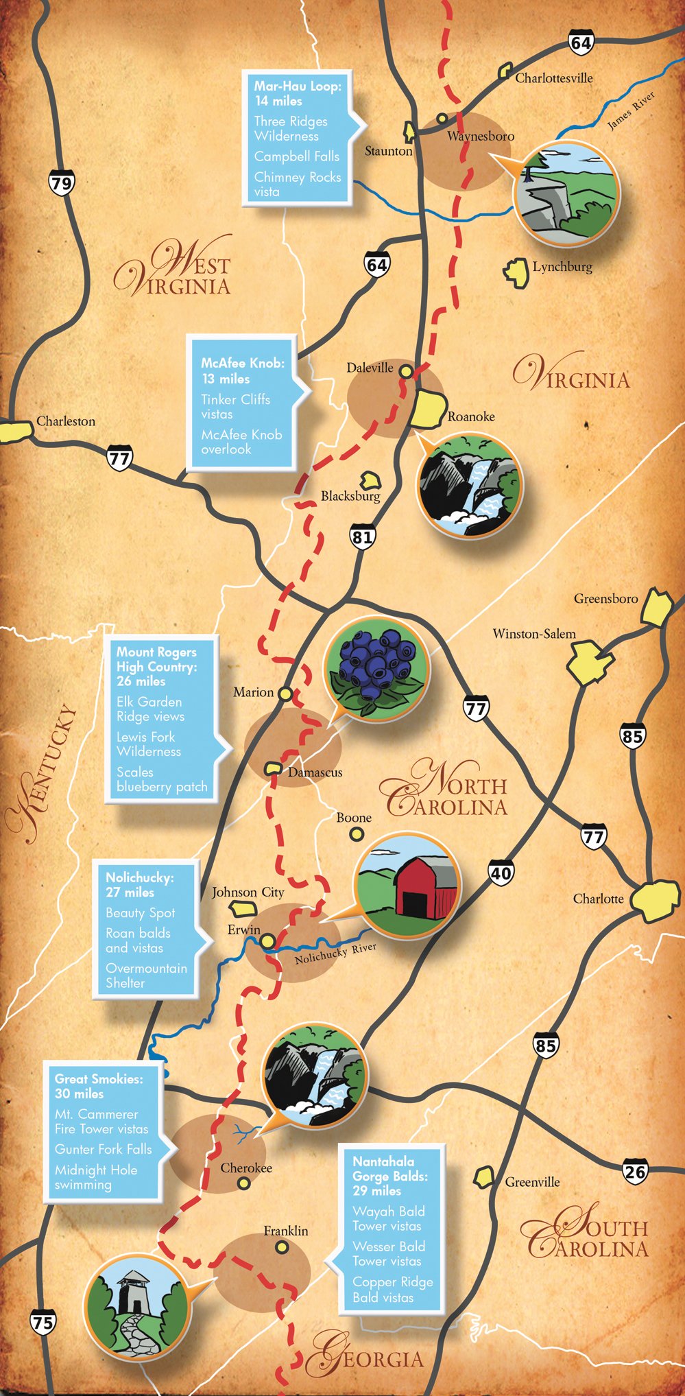
But just about everybody has the time for a section hike, whether it’s a brief one-day getaway, a weekend jaunt, or a week-long excursion. The following Appalachian Trail guide provides mile-by-mile details for six hikes along America’s favorite footpath. We’ve planned your campsites, found the best views, and even offered some side hikes and adventures along the way.
 WEEKEND HIKES
McAfee Knob and Tinker Cliffs
It’s rare that a short, 13-mile overnight hike comes with multiple long range views from beautiful rock outcroppings, but that’s exactly what’s in store for hikers traversing Catawba Mountain and Tinker Mountain near Roanoke. This quick point-to-point hike passes by McAfee Knob—the most photographed spot on the A.T. and one of the most vertigo-inducing cliffs this side of the Rockies. The trip isn’t for those with a fear of heights. And take note, since the area is so popular, camping restrictions are enforced, so only pitch your tent at designated sites.
Day One
Trailhead — Start at the parking lot at Va. 211 and begin the 1,700-foot climb to McAfee Knob.
Mile 1 — Pass by the Johns Spring Shelter.
Mile 2.8 — Pass the Catawba Mountain Shelter and continue hiking as views of the Catawba Valley begin to open up.
Mile 4.5 — Take the McAfee Knob spur trail to reach McAfee Knob, a flat rock outcropping that juts off the side of Catawba Mountain presenting hikers with 270-degree views.
Mile 5.1 — Pick your home for the evening: primitive camping at the Pig Farm Campsite or shelter bunking at the Campbell Shelter a hundred yards farther up the trail.
Day Two
The spring at Catawba shelter is the only reliable drinking source until you drop off the mountain, so fill up before you begin hiking north toward Tinker Cliffs.
Mile 8.3 — Drop into Birckey’s Gap
Mile 10.1 — Reach Tinker Cliffs, where the A.T. traverses the edge of the cliff for half a mile, with views back to McAfee Knob.
Mile 10.6 — Hit Scorched Earth Gap and the Andy Layne Trail. Take the Andy Layne Trail as it drops down Tinker Mountain on its way to Va. Route 779 (Catawba Road). Eventually, the trail will follow and cross Little Catawba Creek.
Mile 12.8 — Reach your terminus, Va. Route 779.
A.T./Mau-Har Trail Loop
Could the 14-mile A.T./Mau-Har loop be the perfect overnight hike? Mike Vaughn of the Tidewater A.T. Club thinks so. “It has everything a hiker would want: a scenic waterfall and several great views. ”This short but grueling loop mixes ridgetop traversing with waterfall-choked canyon hopping for a two-day hiking highlight reel. But contemplative views and scenic swimming holes don’t come easy. Expect almost 7,000 feet of elevation change on this rocky hike.
Day One
Trailhead — Start at Reed’s Gap where Virginia Route 664 meets the Blue Ridge Parkway. Take the white-blazed A.T. south and get psyched for some steep climbs, ridgeline views, and steep descents for your first day.
Mile 0.8 — Greet your first vista, a shot of the small community of Love, Virginia, and its surrounding valley.
Mile 1.6 — Pass an info kiosk, the junction with the Mau-Har Trail, which you’ll climb tomorrow, and the path to the Maupin Shelter. Keep hiking on the A.T., which will enter the Three Ridges Wilderness and climb Bee Mountain.
Mile 3.5 — Another great view can be enjoyed from the Hanging Rock Vista on the side of Bee Mountain.
Mile 4.6 — Summit the wooded Three Ridges mountain.
Mile 6 — Find yourself at Chimney Rocks Vista, the most expansive view of the trip. Half a mile later you’ll hit the Flat Rock Vista, yet another broad view from the edge of the trail.
Mile 7.9 — Take the side trail to Harper’s Creek shelter, which has several flat streamside campsites.
Day Two
Mile 8.6 — Hit the junction with the Mau-Har Trail, turn right up the blue-blazed path, and drop into Campbell Creek Canyon.
Mile 10.1 — You’ll find a campsite and a yellow-blazed spur trail which will take you to the 40-foot Campbell Falls.
Mile 12.3 — After a rocky climb out of the canyon, you’ll cross Campbell Creek several times, eventually following the left fork of the drainage to the Maupin Field Shelter, where the A.T. will take you back to your original trailhead.
Mile 13.9 — Pop out at Reed’s Gap.
THREE-DAY HIKES
Mount Rogers High Country
The 60 miles of A.T. that cut through the High Country offer soaring vistas and well-groomed singletrack, and the 26-mile section from Creek Junction to Fox Creek could be the best weekend of hiking anywhere in the Southeast. The area boasts the tallest mountains in Virginia, enabling you to spend the majority of your time rising and falling between 4,000 and 5,000 feet.
“Without a doubt, my favorite section of the A.T. around here is the Mount Rogers High Country,” says Steve Webb, two time thru-hiker and owner of Sundog Adventures in Damascus, Va. “You’ll see some people, but you can get deep in the woods but also get the high elevation outcroppings.”
Day One
Trailhead — Begin at Creek Junction off State Road 728 north of Damascus, which has a number of outfitters who will run shuttles for this three-day hike.
Mile 2.2 — Pass the Lost Mountain Shelter, which has a good spring and a nice privy. Brace yourself for the 2,500-foot climb from the shelter to the summit of Buzzard Rock.
Mile 3.3 — Cross Star Hill Branch and US 58, then traverse the side of 4,966-foot Beech Mountain.
Mile 6.9 — Summit Buzzard Rock, an outstanding rocky peak with views to the south. Soak in the High Country views from this mile-high perch.
Mile 7.6 — Hike around Whitetop Mountain, staying just below the mile-high elevation mark.
Mile 10.1 — Hike through the Elk Garden parking area, where the Elk Garden Trail and Virginia Highlands Horse Trail meet the A.T. Enter the primitive Lewis Fork Wilderness and traverse the Elk Garden Ridge along Balsam Mountain. Enjoy the awesome views and a handmade bench dedicated to the memory of a “friend and fellow hiker.”
Mile 12.1 — You’re still cruising above 5,000 feet as you pass through Deep Gap. Pass the Mount Rogers Trail on your left then the Mount Rogers Spur Trail.
Mile 13.3 — Hit the Thomas Knob Shelter, your home for the night.
Day Two
Mile 14 — Cruise through Rhododendron Gap at 5,526 feet. In June, expect blooming rhodo at the gap.
Mile 15.3 — Traverse the Wilburn Ridge, taking the blue-blazed Wilburn Ridge Trail, a short detour from the A.T. proper that will take you rock-hopping along massive stone outcroppings.
Mile 16.1 — Cruise through Massie Gap before meeting back up with the A.T. and crossing the Virginia Highlands Horse Trail again, then dip into Grayson Highlands State Park.
Mile 18.2 — Find the side trail for the Wise Shelter and set up camp for the evening.
Day Three
Mile 20.8 — Traverse the wide, flat Stone Mountain on your way to Scales, a massive expanse of blackberry bushes.
Mile 22.5 — Cross Pine Mountain Trail and crest Pine Mountain. As you climb along the trail, look back for a killer view of some of the terrain you’ve just hiked.
Mile 24.2 — Pass the Old Orchard Shelter, where apple trees provide a tasty snack if you time your hike just right.
Mile 25.9 — Come out on State Road 603 at Fox Creek.
Nantahala Gorge Ridgetop
The High Country of North Carolina and the Great Smoky Mountains receive most of the attention from hikers looking for big, expansive views, but this less-trodden section of the A.T. features some of the best fire tower views in the East. On this three day, 29-mile hike, you’ll cruise over balds, visit lookout towers, scramble through rocky outcroppings, and have plenty of scenery to fill up your camera’s memory card.
Day One
Trailhead — Start your hike from U.S. 64 and Winding Stair Gap, heading north on the A.T. Be prepared for steep climbs as you move from the gap toward the high-elevation ridgeline above the Nantahala Gorge.
Mile .9 — Pass a campsite as you continue to climb up the ridgeline, now approaching 4,000 feet in elevation. The next couple of miles will be a steady climb as you roll from gap to gap toward Siler Bald.
Mile 3.7 — Take the blue-blazed Siler Bald Loop (go left) to the bald of the same name for views from an expansive meadow that sits at 4,600 feet in elevation. After the bald, the A.T. moves from the ridgeline to the side of the ridge with creeks and springs.
Mile 9.7 — Hit Wayah Bald (5,342 feet). Wayah is Cherokee for Wolf. On a clear day, expect 360-degree views which include the Smoky Mountains to the north.
Mile 10.1 — Stop for the night at a primo campsite about a half a mile north of the bald that sits just shy of a mile in elevation, or continue on to the Wayah Shelter another half a mile up the trail.
Day Two
Mile 11.9 — Reach Licklog Gap, then enjoy a slow switchback climb and descent to Burningtown Gap before tackling the steep climb to Cold Spring Shelter and Copper Ridge.
Mile 15.4 — Pass by the Cold Spring Shelter.
Mile 16.1 — Enjoy a view of the Little Tennessee River Valley from the Copper Ridge Bald Lookout, then continue cruising above 5,000 feet.
Mile 17.3 — Take the blue-blazed side trail to the Rocky Bald Lookout.
Mile 19 — Hit Tellico Gap and cross state road 1365. If you hike during the spring, look for blooming pink azalea. More wildflowers and the occasional rhodo tunnel mark the path as you climb toward Wesser Bald.
Mile 20.4 — Take the side trail to Wesser Bald Tower, which sits at 4,627 feet and offers commanding views of the Great Smoky Mountains and Fontana Lake. The A.T. drops steeply north of the bald, but after a mile, level campsites can be found near the trail.
Day Three
Mile 21.2 — Pass the Wesser Creek Trail and the Wesser Bald Shelter.
Mile 22.8 — The ridgeline ends at Jumpup, an exposed rocky outcropping that sits at 4,000 feet. From the knob, you can see Cheoah Bald and the Nantahala Gorge. Soak up the view before tackling the steep descent. On the way down, you’ll pass the Rufus Morgan Shelter.
Mile 26.9 — Reach your terminus as the trail passes through the Nantahala Outdoor Center.
FOUR-DAY HIKE
Great Smoky Mountains National Park
The Smokies portion of the A.T. is a classic Southern backpacking trip, and it receives the crowds to prove it. Shelters are often packed during the summer; reservations are required for shelters and campsites. But don’t let the crowds discourage you. Weekdays are less populated, and according to Tim Bigelow, president of the Smoky Mountains Hiking Club, if you walk a few miles from any trailhead, the crowds disperse, because of a lack of access roads.
This four-day backpack combines ridge hiking with gorgeous streamside walking through deep river gorges. You’ll enjoy views from a beautifully renovated fire tower, have options to bag 6,000-footers, and swim in ice-cold mountain pools.
Day One
Trailhead — Big Creek Ranger Station. Take the 2.1-mile Chestnut Branch Trail to meet up with the A.T.
Mile 2.1 — Intersect the A.T. just south of the Davenport Gap Shelter. Hang a left and climb toward Mount Cammerer. From the ranger station to the firetower, you’re looking at a 3,000-foot gain.
Mile 4.3 — Take the side trail to Mount Cammerer Fire Tower on the northern edge of the park at 4,928 feet.
Mile 7.1 — Reach the Cosby Knob Shelter just shy of the Cosby Knob summit, and set up camp for the night.
Day Two
Mile 12 — Keep an eye out for a side trail to Old Black, a 6,370-foot peak with a relatively easy bushwhack off the A.T.
Mile 12.8 — If you’re up for a hardier bushwhack, take the unofficial Mount Guyot side trail to the fourth highest mountain in the Southern Appalachians (6,621 feet).
Mile 14.8 — Reach Tri-Corner Knob Shelter, your home for the night.
Day Three
Mile 19.8 — Go left on the Gunter Fork Trail, which will drop more than 1,500 feet in two miles as it falls off the ridgeline into an isolated gorge. This trail sees little activity compared to other paths in the park.
Mile 22 — Check out Gunter Fork Falls, a 25-foot waterfall with an additional slide just above the trail crossing.
Mile 24.1 — Take a right on the Camel Gap Trail and hike half a mile to Upper Walnut Bottom Campsite.
Day Four
Mile 25.1 — Take the Big Creek Trail north as it follows the river of the same name. The trail is actually an old railroad bed that gradually drops 1,200 feet.
Mile 28. 1 — Take the short side trail to Mouse Creek Falls, a 45-footer surrounded by hemlocks.
28.8 — Adjacent to the trail, you’ll see Midnight Hole, where the river drops six feet over boulders into a deep, cold plunge pool.
30.2 — Reach the Big Creek campground and ranger station where your car awaits.
FIVE-DAY HIKE
Nolichucky River to Overmountain
If variety is the spice of life, then this five-day stretch is the spiciest backpacking trip on the A.T. You’ll start at the Nolichucky River where rafting companies bank the class IV river, climb through dense spruce forests, apple orchards, and wildflower patches before reaching 6,000 feet in elevation where you’ll do some classic “bald hopping.”
“You hit this open bald and get 360-degree views. Then you hit another, and another,” says Jacob Mitchell, hike leader for the Tennessee Eastman Hiking and Canoe Club, which is responsible for maintaining this stretch of the A.T.
Plan your hike so you spend at least one night at the Overmountain Shelter, a converted red barn perched in a meadow with dramatic views. And save enough energy to tackle Little Hump and Big Hump mountains, with long exposed walks through tall grass and views that rival anything on the trail.
Day One
Trailhead — Start at the Chestoa Bridge in Erwin at the Nolichucky River. Start hiking the white-blazed A.T. north, crossing Jones Branch several times.
Mile 4.2 — Pass the side trail to the Curley Maple Shelter.
Mile 8.3 — Walk through Indian Grave Gap, tracing the North Carolina/Tennessee border.
Mile 10.5 — Hit Beauty Spot, an open meadow with a view that lives up to its name: lots of wildflowers during the spring, ripe berries in late summer, and an ideal campsite for your first night.
Day Two
Mile 13.6 — Summit the 5,180-foot Unaka Mountain, which is covered by a dense spruce forest.
Mile 16.3 — Pass the Cherry Gap shelter.
Mile 19 — Cross Iron Mountain Gap, then pass through an apple orchard at Weedy Gap.
Mile: 25.4 — Bed down at the Clyde Smith Shelter (4,400 feet), making sure to wake early for the sunrise view over the mountain to the east.
Day Three
Mile 26.3 — Summit Little Rock Knob, which is just shy of 5,000 feet, but has tremendous views of the mountains you’ll soon be crossing from a rock outcropping on the summit.
Mile 30.1 — Cross the Cloudland Hotel site, an open area with awesome views and spring wildflowers, and a side trail to Roan High Bluff. Take the short detour to the Roan High Bluff overlook.
Mile 32.8 — Call it a night at Roan High Knob Shelter. At 6,285 feet, the converted fire warden cabin is the highest shelter on the entire A.T. Find the true summit of Roan High Knob at a rocky patch nearby.
Day Four
Mile 34.3 — Cross Carver’s Gap (5,512 feet), then begin the easy climb to Round Bald. Soon after Round Bald, you’ll hit Jane Bald, another open meadow with panoramic views.
Mile 36.2 — Arrive at the intersection with the Grassy Ridge Side Trail. Take the 0.5 mile blue-blazed path that leads to yet another 6,000-foot grassy bald.
Mile 37.6 — Pass the trail to the Stan Murray Shelter.
Mile 39.2 — Walk into the Overmountain Shelter, below Yellow Mountain Gap at the junction of the Overmountain Victory Trail. The big red barn overlooks Roaring Creek Valley for what some say is the best view from any shelter on the trail.
Day Five
Mile 40.8 — Cross Little Hump Mountain, your first bald for the day.
Mile 43.6 — Summit Hump Mountain, a 5,587-foot towering grassy bald with the requisite big views.
Mile 46 — Cross through Doll Flats, a popular primitive campsite.
Mile 47.5 — Reach the Apple House Shelter, which was originally designed to hold explosives for a nearby quarry.
Mile 48 — Hit the pavement of US19E, which is your hiking terminus. Shuttles can be found a few miles west at the community of Roan Mountain. •
