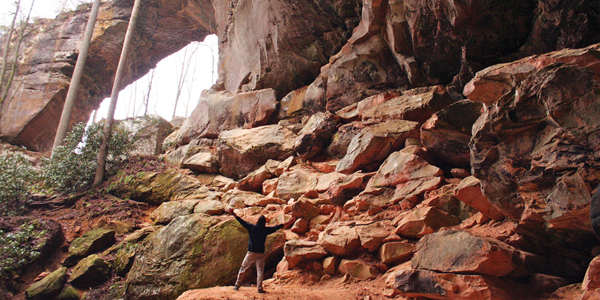
- Rock Bridge Loop: In just 1.5 miles, you’ll drop down a series of steps to the bottom of a creek gorge, walk into a small rock shelter, pass by high cliffs, see Creation Falls (an arch in the making), and peep Rock Bridge Arch. Swift Camp Creek runs through the middle of this sandstone arch, making a perfect natural bridge.
- Princess Arch Trail: At the end of Chimney Top Road off Route 715, the .5-mile Princess Arch Trail finishes with a small cave and big cliff. Princess Arch is only eight feet high, but it’s 32 feet long, and as impressive as any other rock feature in the Red. You almost feel guilty for getting this big a payoff after such a short hike.
- Angel Windows: Directly off Route 715, a .3-mile trail leads you to Angel Windows, a cliff with a series of recessed caves and small arches. If there’s been rain, keep hiking past the windows and you’ll find a small trickle of a waterfall over a rock shelter.
The Day Hiker
Aside from the Sheltowhee Trace, Kentucky’s long trail, the 60 miles of trail within the gorge are ideal for day hiking. For the most part, distances between points of interest are manageable and the high number of intersecting trails makes loops easy to configure.
“With all the short circuit hikes, it’s as if the trail system was built with day hikers in mind,” says “Mad Mountain” Mike Hughes, a backpacker and hiker who’s been leading trips into the gorge for three decades. Set up camp at a central location, like Koomer Ridge Campground, and then choose from dozens of gorgeous day hikes within the Red. Here are three you shouldn’t miss.
- Gray’s Arch Trail: If you’re only going to see one arch in the Red, make it Gray’s. Gray’s starts on the edge of a cliff and spans 80 feet long and 50 feet high. Leading up to the base of the arch is a massive rock shelter with a fine sandy floor littered with boulders for scrambling. It’s a relatively remote arch, tucked into a ravine at the end of a 1.3-mile one-way hike on the Gray’s Arch Trail. The arch and rock shelter are so large, they create an echo when you talk.
- Auxier Ridge: Combine the Courthouse Rock Trail and Auxier Ridge Trail for a 5-mile loop that keeps you high on a ridgeline for good views of mini gorges and plenty of interesting rock features. Auxier Ridge is a cliff top hike that narrows onto a sandy, rocky ridge with views of Haystack Rock and Double Arch and Raven’s Rock. The trail ends at the base of Courthouse Rock, which has a maze of boulders and an optional scramble to the top of the massive rock feature. Pick up Courthouse Rock Trail for a walk through the woods back to the trailhead. You could also tack on Auxier Branch and Double Arch Trails if you wanted to turn this into an overnighter.
- Sheltowee Side Trip: Just west of the Clifty Wilderness off Route 715, hike the 0.8-mile Bison Way Trail, then hang a left on the Sheltowee Trace Trail, a rugged backcountry path that runs for 268 miles through Kentucky. You’re only hiking the Sheltowee for a little over a mile on this trip. Head west on the Sheltowee, passing a couple of unmarked side trails on your way to Indian Arch, a short but impressive sandstone span along the trail. Head back the way you came, except this time take the first unmarked trail on your left, heading steeply up the bank of the mountain. You’ll quickly find yourself at a rock and root scramble that will lead you to the base of the Indian Staircase, a series of hand carved rock “steps” cut into the side of an almost vertical sandstone face. At the top of the cliff, you’ll find a large rock house that’s 60 feet high and at least 100 yards long. The unofficial trail continues east and west; both directions will take you back to the Sheltowee.


