The sun is just beginning to set on the hills west of Gatlinburg as I stand naked on the side of the road, examining two giant blisters on my bare feet (one on each big toe). They’re bulbous, opaque, and large enough to look like I’ve suddenly grown a sixth and seventh toe. My trail shoes began to rub me wrong around mile 13. The blisters aren’t even number one on my list of concerns. I ran out of water two miles back, I’m famished, and I’m already sore in places I didn’t know could get sore. In other words, it was a good day in the woods. Not just a good day. A big day in the woods, which is exactly what I needed.
Okay, technically, I’m not naked. I have a towel wrapped around my waist as I stand beside my car changing from my hiking clothes into something clean enough to wear in public. It’s a dance I’ve done countless times before, but thanks to my close proximity to downtown Gatlinburg and the heavy drive-by traffic, I’ve never felt this exposed. People honk. Perverts. I’m in a hurry to change because there’s moonshine waiting for me and maybe an all-you-can-eat pancake dinner. This is the beauty of adventure on the edge of Gatlinburg. Any wild expedition can immediately be followed by any sort of Appalachian-style decadence you can imagine. Fried chicken palaces? Check. Go-kart racing? Check. Moonshine distillery? Check.
I’ve spent the better part of the day running and hiking up the side of Mount LeConte, a 6,593-foot mountain on the western edge of Great Smoky Mountains National Park, and I have a hankering for a fantastically large meal and some homegrown liquor.
Judge a mountain strictly by its height and LeConte isn’t that impressive. Sure, it’s a 6,000-footer, higher than most mountains in these parts, but there are five other mountains with loftier summits. LeConte isn’t even the highest mountain inside the GSMNP. That title belongs to Clingman’s Dome (6,643’). But what LeConte lacks in overall height, it makes up for in sheer vert. While it’s not the highest mountain around, Mount LeConte is widely recognized as the tallest mountain in the East, with the greatest vertical rise from its immediate base (1,292’) to its summit (6,593’). Ascend the western flank of LeConte, and you’ll climb more than a mile of elevation, a feat that can’t be duplicated anywhere else on the right side of the Mississippi. Even climbing some of Colorado’s famed 14,000-foot peaks won’t get you 5,000 feet of elevation gain. There’s even more elevation gain on the trip up LeConte than there is up the side of the famous Long’s Peak, a fourteener on every peak-bagger’s to-do list that nets a mere 5,000 feet of vert in a 15-mile round trip hike.
Translation: LeConte is legit. And climbing a legit mountain from the bottom to the top is exactly the kind of adventure I need at this point in my life. I’m not sure how it happened, but one day, I woke up and I was a 35-year-old out-of-shape dad. My formerly adventurous lifestyle–once filled with multi-day mountain bike trips, afternoon-long trail runs, and the occasional rock climbing excursion–has transitioned into trips to the playground, mommy and me classes, and work deadlines. And I can’t find my abs. I wouldn’t say I’m chubby, but I’m definitely soft. I blame the kids. And the wife. And the job. And TV. And chicken wings. Definitely chicken wings.
What I need is a dramatic adventure that will kick-start a new direction. I want to shock my body and mind back into the mountain lifestyle. Climbing LeConte will signify a new me. No more beer and chicken wings. No more Seinfeld marathons. More singletrack. More night rides. More dawn patrol. Goodbye soft me. Hello new hardcore me.
The shortest route to the top of Mount LeConte is via the dramatic Alum Cave Trail. In just over five miles, you’ll pass through a massive rock house, teeter on the edge of a cliff, and soak in some of the biggest views inside the park. Alum Cave is without a doubt the best way to summit LeConte, but it gains less than 1,000 feet of elevation from beginning to end. In order for my summit expedition to be truly epic, I need to bag the full mile of elevation. To do that, you have to climb the western face of the mountain, starting essentially on the edge of downtown Gatlinburg, and traverse a total of 20-odd miles of singletrack, doubletrack, and road. Twenty miles and 5,300 feet of elevation gain is a big day for a person in good shape. For a person of my current stature, it’s borderline suicidal.
In order to give myself the best chance at finishing the summit, I planned on beginning the jaunt at 7am. After trouble with the kids back at home, a “quick” stop for my traditional pre-adventure egg and cheese McMuffin breakfast, and a detour to the Sugarlands Visitor Center because I left my map at home, I don’t set foot on a piece of dirt until 11am. That gives me roughly seven hours to run/hike 20 miles up and down the East’s tallest mountain.
The adventure begins on Twin Creek Trail, a mossy-rock lined piece of singletrack that starts on the edge of town and follows a small creek that parallels the Roaring Fork Motorway. Twenty feet into the run, I trip over a rock and land head-first. I’m nervous because of the late start. Also, the 3D relief map of the park inside the visitor’s center has me on edge. I spent a few minutes ogling over the bumpy landscape while picking up the trail map. LeConte rises so steeply, and so independently from the valley floor, it looks like the cartographer made a mistake.

I catch glimpses of great rock walls, hand stacked about waist high as I climb slowly, but steadily through the valley floor. I don’t have time to explore because I’m trying to beat the sunset. After a few miles of gradual climbing, I hit the Rainbow Falls Trailhead and the junction for Bullhead Trail, which is where the climbing really begins. Bullhead gains 4,000 feet over seven miles. Much of that elevation comes up front as the trail passes through your typical rhodo tunnel. Eventually, the trail turns into a sidecut path that cuts through boulderfields with massive rock crags and the occasional small rock house shelter. Once the trail climbs to a skinny ridgeline, it becomes flat and runnable and offers a great view of downtown Gatlinburg. You can see the replica of the Space Needle and everything. Driving through Gatlinburg, the town can seem overwhelming and larger than life, with its carnivalesque atmosphere. From above, it all looks so tiny. From this vantage point, you can see how the forest creeps right to the edge of town. There’s no real suburban buffer around Gatlinburg, like with most towns. Here, it’s just wilderness right against kitschy neon.
Say what you will about Gatlinburg, it could be the only place in the country where you can start a monster hike that gains a mile of elevation just a few blocks from a laser tag/putt putt complex.
I run as much of the ridgeline as I can before the climbing starts in earnest again. I’m wearing the most cushioned trail shoe on the market because I have knee and hip problems. There, I said it. My hip hurts. I’m getting old. Eight miles into the run/hike (rike?) I begin to wonder if my doctor would have cleared me for this adventure.
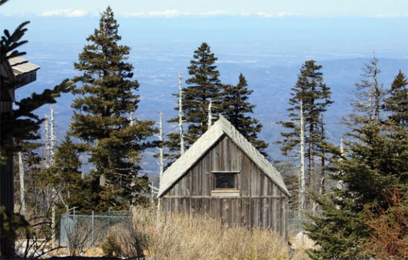
The wind is howling over the trees and there’s two inches of snow and ice lingering on the ground as I approach the summit of LeConte. With a mile of elevation separating the summit and the valley, it’s a completely different season up here. A completely different ecosystem too, one dominated by evergreen spruce and fir. There’s a lodge at the top–a handful of cabins and a mess hall that’s closed for the winter but bustling with guests during the warmer months. The closest road to the lodge is six miles away, so the caretakers have supplies hauled up by llamas.
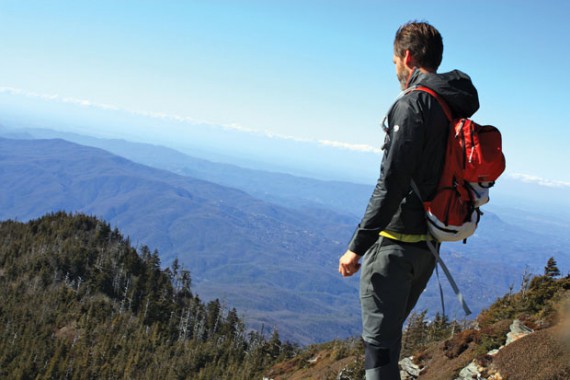
I wander past the gray and weathered buildings looking for some sort of view, a dramatic reward for climbing a full mile of vert just for the hell of it. I find Cliff Tops, an outcropping with a broad view into the park to the east. I can see slopes draped with evergreens and the spines of rocky ridges below.
The climb up LeConte was difficult, but not brutal. The brutality is saved for the run down the mountain. After ditching the summit view, I have just over nine miles of trail and road to traverse before I’m back at my car and headed into town for post-adventure grub. On a good day, I could knock that out in a couple of hours. Today, the ice and snow on Rainbow Falls Trail slows me down considerably. Plus, my knees are killing me, I’m chafing in delicate areas and my hip pops on every other step. The descent is way more painful than the climb. I have trouble mustering the energy to run the final four miles once I’m back in the valley, but the dropping sun gives me enough reason to push harder. Plus, there’s moonshine waiting for me. Maybe a trip up the fake Space Needle. Gatlinburg, Tennessee, with its main street of mini theme parks, over-the-top restaurants, and ninja sword shops, is one of the most surreal little towns in the country. And I mean that as a compliment. Think Appalachian Las Vegas.
After changing clothes on the side of the road, I head straight for Ole Smoky Distillery, one of the South’s first legal moonshine crafters which has a tasting room on Gatlinburg’s strip. The moonshine tastes better than it should, so I ask the overall-clad gentleman behind the bar to take me “around the world” with the free samples: a little Apple Pie, a little Grape Lightening, a little of the Original, perhaps a moonshine-soaked cherry or two.
I eschew the pancakes for a Mexican feast, largely because the Mexican restaurant has an escalator to the second-floor dining room and I’m in no shape to climb stairs. It also has a mechanical donkey. I contemplate signing the waiver and giving the robotic jackass a go, but my legs and back are already starting to ache. I’m going to pay for this adventure for the next week.
It’s hard for me to reconcile the fact that just a few hours ago, I was slogging through a 20-mile hike with 5,200 feet of vertical gain, much of which was packed with ice and snow, and now I’m sitting next to a mechanical donkey, drinking a giant margarita and staring at a glowing strip of lights. But that’s the charm of this corner of Great Smoky Mountains National Park. The wild and the garish practically hold hands. Personally, I think it’s the perfect place to kickstart my healthy new adventurous life. Now, another fish taco and margarita. •
Join the Mile High Club
To gain the full 5,300 feet, you need to start on the edge of downtown Gatlinburg, walking Cherokee Orchard Road until you meet the Twin Creeks Trail. Pay $5 at one of the lots near the Space Needle to park all day. Give yourself a full day to knock out the 19-20 mile hike. Combine Twin Creeks Trail with Bullhead and Rainbow Falls Trails for a lollipop loop.
Gear Up
The Nantahala Outdoor Center has a large outfitter on Gatlinburg’s main drag not far from where the hike begins.
Drink Up
Ole Smoky Moonshine is a bit campy, but the shine is good. If you want something easy to handle, go with the Apple Pie. olesmokymoonshine.com


